


Turkish bases are thinning Kurdistan’s border woodland, satellite data show, but far less than claimed
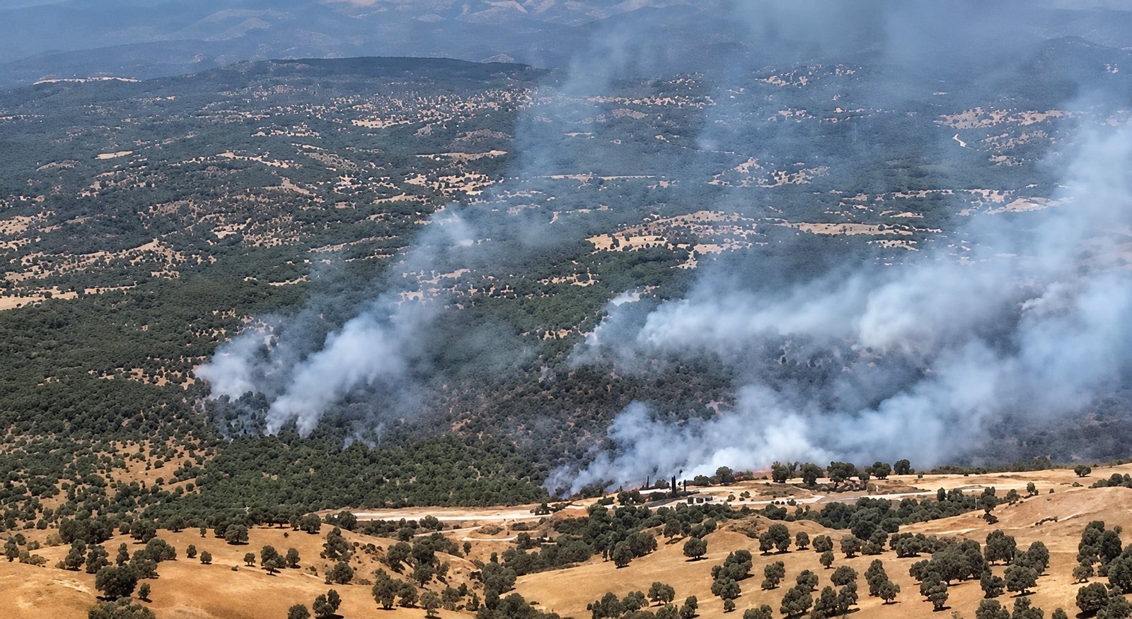
Trucks carrying freshly felled timber have been filmed leaving the mountains of northern Amedi district, in Duhok province, for Turkish military positions inside the Kurdistan Region. The traffic is not new. Residents of several villages in the area, where Turkey has steadily expanded its presence since 2019, said on 2 October that it is seasonal: each autumn, five to 15 loaded trucks a day supply nearby Turkish outposts until the cutting stops in late autumn. The villagers themselves are barred from felling trees or even gathering firewood in the same areas. The trucks pass through checkpoints manned by forces of the KDP, which controls Duhok, so the party’s security apparatus is at the very least aware of them.
The issue drew wider attention after opposition accounts on social media accused Turkey of large-scale logging in Amedi. Rudaw, the broadcaster owned by Kurdistan Region President Nechirvan Barzani, then reported from the area. Its witnesses described two sources of timber: some enters from Turkey through Sarzeri, a border crossing between the Kurdistan Region and Turkey in northern Amedi, and some is felled inside the Kurdistan Region, with five to 10 trucks a day taking it to Turkish outposts during the cutting season. A village head said that residents who had returned to the area, now a no-go zone, found trees up to 80 years old cut down, including a poplar in his own village.
Kurdistan24, a channel closely aligned with KRG Prime Minister Masrour Barzani, answered on 4 October with a field report that dismissed the claims as false. It said no trees had been cut inside the Kurdistan Region and that camera footage at Sarzeri showed loaded trucks arriving from Turkey, with the wood sold in Duhok province. Duhok governor Ali Tatar, a KDP official, took the same line that day, saying the timber in the footage had been felled in Turkey and that no trees had been cut in the Kurdistan Region in the current period, although he acknowledged cutting in its border areas in previous years. The divergence between the two channels partly reflects their editorial cultures: Kurdistan24 keeps close to the prime minister’s line, while Rudaw, though owned by the president, allows its reporters more latitude.
The exchange revives a dispute that first erupted in 2021 over whether Turkey is stripping the region’s northern forests, and whether the wood ends up in Turkish markets or furniture workshops. A TNC satellite analysis of every district of the Kurdistan Region over 25 years suggests that both sides overstate their case. Woodland loss around Turkish roads and outposts is real, has roughly doubled since before the Claw operations and survives checks for drought and fire. It also amounts to a few tens of square kilometres, a fraction of what a commercial timber trade would require.
Context: Turkey has maintained a handful of bases in the Kurdistan Region since the 1990s, but its footprint expanded sharply with the Claw operations against the PKK (Kurdistan Workers’ Party). Launched in 2019, the campaign pushed Turkish forces into a chain of border mountain areas, including Haftanin, Metina, Avashin-Basyan and Zap in Duhok province and Hakurk in Erbil province. The number of Turkish bases rose from about 15 in 2018 to at least 136, most of them on ridgelines in Amedi, Zakho and the Sidakan area of Soran, and newly built military roads now link them. In February 2026 a peace monitoring group described one such network across northern Amedi and said the area had been heavily deforested to build it.
The cutting first became a political issue in 2021. Sheikh Mus Babat, a Kurdish contractor from the Turkish side of the border, said his company had built a 74 km road into Haftanin and another firm a 38 km road elsewhere in the border area, and that the wood served only to heat Turkish troops and was not sent to Turkish cities. His Babat tribe is influential in Uludere district of Sirnak province, directly across the border from Amedi, and has long been prominent in the village guards, the state-armed Kurdish militias that have fought the PKK for decades.
Iraq’s then president, Barham Salih, and the agriculture ministries in Baghdad and Erbil accused Turkey of damaging the forests and moving timber across the border for sale. Turkey’s defence ministry called the claims entirely false, and its ambassador in Baghdad dismissed them as disinformation. Reving Hiruri, a KDP lawmaker from Zakho, said Turkish companies were selling the wood in the Turkish border provinces of Sirnak and Hakkari, and an Iraqi MP claimed that 450 tonnes a day were leaving, including walnut and plane trees for furniture.
There is a precedent on Turkey’s own side of the border. In 2020 and 2021 the Turkish authorities cleared woodland on Mount Cudi and surrounding areas of Sirnak province, citing security. The provincial bar association said 8% of Sirnak’s forests were destroyed between February and September 2021 alone, and the timber was sold in markets as far away as Urfa.
Any assessment also has to reckon with two other pressures on the region’s woodland. Fire is the largest: about 356 km² of forest burned each year between 2001 and 2024, 77% of it in Duhok and Sulaimani, and about a quarter of the region’s conflict hotspots overlap with fire hotspots, including one in Amedi. Drought is the second. Rainfall fell to 236 mm in 2021 and 1,650 of the region’s 5,276 springs had dried up by 2022, before rainfall recovered to 653 mm in 2024.
Analysis: The National Context’s analysis combines three satellite records that trade length of history against detail. NASA’s MODIS satellites provide the longest consistent record, from 2001, but at a coarse resolution of 250 m. The US Landsat satellites are sharper, at 30 m, and allowed TNC to look back to 2004, well before Turkey’s expansion. Europe’s Sentinel-2 satellites offer the most detailed view, at 10 to 20 m, with full coverage of the region since 2017. Using all three allows each finding to be cross-checked against the others.
In each record, TNC measured what this article calls a “marked drop”: a fall in summer greenness of at least 0.1 on the standard vegetation index (NDVI), beyond the typical change in woodland within about 3 km. Benchmarking each spot against its surroundings strips out the effects of weather, image dates and sensor differences, and districts are compared at matching elevations. Greenness is a proxy for vegetation and does not count trees, so a drop can reflect cutting, fire, drought, disease or grazing, and the tests below are designed to separate these causes. Satellites also cannot show where felled wood ends up.
The long-term record rules out a collapse. Across the MODIS record, woodland greenness has increased in every district of the Kurdistan Region, including Amedi and Zakho, and less than 2% of mountain land above 900 m in any district has lost green cover in 25 years. Circulating figures that put forest decline at 19% in Amedi and 33% in Duhok cannot be reproduced, and Duhok district, which has no Turkish bases, shows no sign of losing a third of its woodland. What the record does show is a slow relative decline in the border belt, defined here as woodland within 25 km of Turkey in Amedi, Zakho and Mergasur, a pattern that points to localised loss.
Sentinel-2 imagery pinpoints where that loss is. Between 2017/18 and 2024/25, 5.6% of Amedi’s woodland showed a marked drop, the highest share of any district, followed by Zakho at 4.8% and Mergasur at 3.8%. Elsewhere the share was 2.8% in Akre, 2.5% in Soran, 2.1% in Penjwen on the Iranian border, 2.0% in Duhok and 1.7% in Pshdar.
Elevation accounts for part of this, since high-altitude woodland is more sensitive to drought, but Amedi is not the region’s highest district. Compared band by band with the woodland of Akre and Soran, Amedi is similar below 1,200 m, at 4.1% against 3.0% below 1,000 m and 4.4% against 3.8% between 1,000 and 1,200 m. Higher up, the gap widens: 5.9% against 1.7% between 1,400 and 1,600 m, 9.7% against 2.8% between 1,600 and 1,800 m, and 19.7% above 1,800 m, against 1.6% at the same altitude on the Iranian border. Adjusted for elevation, Amedi lost about 12 km² more woodland than comparable terrain elsewhere, about 2.5% of its total.
Those high bands are where Turkey’s army has built. Amedi’s 947 km² of land above 1,400 m holds 131 km² of woodland, of which 10.7 km² showed a marked drop, in nine clusters. Satellite images show new or upgraded roads in five of them and cleared hilltop sites in three, while the ninth, on Mount Gare south of Amedi town, bears the signature of fire. The cleared hilltops are consistent with helicopter landing sites: Turkey supplied its new bases in northern Amedi by helicopter for about three years after the 2021 operation, until military roads reached them.
Three tests examine whether the link to Turkish military activity holds. The first draws on an independent record of where Turkey’s army has fought, the Uppsala Conflict Data Program’s database of Turkey–PKK clashes and air strikes, which logs incidents and does not record base locations. At every elevation, woodland near recorded Turkish military activity lost about three times as much as woodland without it. Proximity to the border alone made little difference: 2.0% of border-belt woodland without recorded activity showed a marked drop, close to the 1.8% further inland, against 6.1% where activity was recorded. Further inland, where the activity consists mostly of air strikes, the figure was about 2.5%, and on Mount Gare 0.8%. The loss therefore tracks Turkish ground presence on the border ridges far more closely than fighting in general.
The second test asks whether these areas were already losing trees before Turkey arrived, and Landsat imagery shows they were not. Woodland that later saw five or more recorded Turkish military events lost 0.08% a year between 2004/05 and 2010/11, less than the 0.17% in areas that never saw fighting. Its rate rose to 0.18% a year by 2016/17, as fighting resumed after peace talks collapsed in 2015, and to 0.34% a year from 2016/17 to 2024/25 (0.44% on Sentinel-2), while woodland without fighting moved only from 0.13% to 0.20%. The border belt as a whole followed the same trajectory, from 0.09% to 0.18% to 0.34% a year, while inland woodland held at around 0.15% to 0.20%. Rates along the Iranian border have been comparable throughout, at 0.35%, 0.18% and 0.39% a year, so a rate of about a third of a percent is not unusual in the Zagros. What distinguishes the Turkish border is that its rate started low and climbed in step with Turkey’s expansion, and measured on current tree cover alone it is now the highest in the region.
The third test separates fire from cutting. Only 19% of the border belt’s loss since 2017 falls within burn scars mapped by satellite, and even with those excluded, its loss rose from 0.06% to 0.12% to 0.27% a year, against 0.14%, 0.11% and 0.17% for inland woodland. Fire is nonetheless rising in the belt, where the share of woodland affected grew from 5% to 10% to 17%. Some of that may stem from shelling and air strikes, but the data cannot say how much.
Drought is the strongest alternative explanation, because the dry years of 2021 and 2022 coincided with Turkey’s expansion. If drought were the main driver, losses should have eased once the rains returned. Splitting the Sentinel-2 record at the drought shows that they did in inland woodland, from 0.19% to 0.15% a year, and in Halabja, from 0.70% to 0.31%. In the border belt, the rate rose from 0.63% to 0.80%. Within the same northern climate zone, woodland near Turkish military activity went from 0.41% to 0.67% while woodland without it fell from 0.31% to 0.13%, leaving the former losing about five times as fast after the drought. These shorter windows produce higher annual rates than the full period because they capture dieback that later recovers, so the direction of change is what matters.
Halabja illustrates what drought-driven loss looks like. Its total is similar to Amedi’s and Zakho’s, but 61% of it lies on valley floors and none on ridges, and 81% occurred during the drought, as village orchards and riverside trees in the Hawraman valleys along the Iranian border died back when springs failed. Amedi’s loss, by contrast, sits on ridges and high slopes, much of it along new roads, and kept growing after the rains returned.
The spatial pattern also shows whether the cutting is systematic. Commercial logging tends to spread across accessible forest, but in the border belt the top tenth of 1 km blocks account for 89% of all loss, and about four in five blocks show none. Within these hotspots, the loss follows roads. In the Metina mountains, a main target of the 2021 Turkish operation, 29% of woodland within 250 m of a new road showed a marked drop, against about 10% further away, and the losses came in 2023 and 2024, the years a switchback road and then a ridge-crest road appeared. Road surfaces account for only 0.4 to 0.9 km² of the 7.7 km² of marked drop in the area. Part of the remainder burned during the fighting of 2021 and 2023, and the rest lies beside and below the roads, consistent with clearance for construction, sightlines around positions and cutting wherever trucks can reach. That matches both Babat’s 2021 account of road building and residents’ accounts of firewood trucks today.
The scale of the loss is limited. Across the border belt, about 36 km² of woodland, out of roughly 1,300 km², has shown a marked drop since 2017, and about 20 km² of that exceeds what comparable woodland lost elsewhere, 12 km² of it in Amedi. That equates to 0.34% to 0.5% of the belt’s woodland a year, against about 0.2% for woodland in the region without Turkish military activity, about 0.16% in Iran’s Zagros oak forests and about 0.25% for gross forest loss worldwide. Woodland on the Turkish side, in Sirnak province, lost more on the same measure, at 0.66% to 0.81% a year.
War zones elsewhere have suffered far heavier losses. Syria’s coastal forests lost 24% of their cover between 2010 and 2020 and western Syria 19% between 2010 and 2019, more than half of Afrin’s forest cover was reported lost within about three years of Turkey’s takeover, and on Ukraine’s front lines 5% to 16% of forest was damaged in a single season. Studies of tropical conflicts have found forest loss several times more likely in war zones.
The same figures cap the alleged timber trade. Even if every affected hectare were dense, mature woodland at the top of published Zagros biomass estimates, about 76 tonnes per hectare, the excess loss would yield at most about 20,000 tonnes of wood a year, and the entire marked drop about 35,000 tonnes. The 2021 claim of 450 tonnes a day equates to about 165,000 tonnes a year, five to eight times that ceiling. Actual yields are likely far lower, because most of this woodland is scrub oak coppiced over generations. Such wood is firewood grade and of little use to furniture makers, and even the theoretical maximum would amount to about a tenth of a percent of Turkey’s annual industrial wood harvest of about 28 million cubic metres. Smaller-scale sales, such as surplus firewood sold in Sirnak or Hakkari, or the felling of individual walnut and plane trees in the valleys, cannot be ruled out, but a trade on the scale alleged can.
For the current season, the picture remains incomplete. Between late September 2025 and late September 2026, the most recent cloud-free images, 0.31% of the border belt’s woodland, about 150 hectares, showed a strong drop in greenness, less than the 0.69% recorded in the Akre and Soran woodland used for comparison. Within 3 km of the outposts residents named, losses ranged from 0.2 to 4.3 hectares, with no visible clearing. The one clear change lies a few kilometres south of one of those outposts, where a pale strip roughly a kilometre long has appeared along a wooded valley. It joins an existing road, is most likely a new secondary road and covers a couple of hectares. None of this contradicts the residents, who describe cutting that begins in autumn, after the latest clear images, and selective cutting for firewood is difficult to detect at this resolution. The image from 4 October is too cloudy to assess, so the next clear pass will show whether this season’s cutting leaves a mark.
Measured against this record, the official account holds only in part. The governor’s acknowledgement of cutting in previous years matches the excess loss since 2017. Rudaw’s witnesses confirm that some timber does arrive from Turkey, which is plausible given that the Turkish side has lost woodland faster and timber from the Sirnak clearances was sold on the open market. The claim that no trees have been cut this season, however, cannot yet be verified from orbit, and Rudaw’s witnesses dispute it. Nor are the two accounts mutually exclusive: timber entering at Sarzeri says nothing about the trucks that residents and Rudaw’s witnesses describe moving inside the Kurdistan Region toward Turkish positions. Sarzeri is also one of seven crossings the KRG has asked Baghdad to recognise, which raises the question of how a daily timber trade through it is recorded.
The evidence supports a narrower conclusion than either side of the debate. Turkey’s military expansion has left a measurable mark on the Kurdistan Region’s northern woodland: loss in the border belt has roughly doubled since before the Claw operations and runs about three times higher near Turkish military activity than elsewhere at the same elevation. The excess was absent before the build-up and survives checks for drought and fire, so Turkish denials that its forces harm the forests do not hold up. At the same time, there is no sign of forest-wide clearance or of a commercial timber trade on the scale alleged, since the loss is concentrated along roads and around positions and amounts to a few tens of square kilometres.
The damage is still significant. It falls on the region’s highest and least accessible oak woodland, in areas closed to villagers and outsiders alike. Roads and cleared hilltops are effectively permanent, the rate of loss has risen in each period since 2004, though not in the latest year, and with at least 136 bases in place, demand for heating wood will return every winter. Without regular, independent monitoring, the debate will keep oscillating between official denial and exaggerated claims while the real, smaller losses go unrecorded.


