


Four Maps That Explain Iran’s Complex Kurdish-Populated Provinces
To outsiders, the Kurdish region of Iran, often called Rojhelat (eastern Kurdistan) among Kurds, might appear as a monolithic ethnic block clinging to the Zagros Mountains along the Iraqi and Turkish borders. Zoom in, and a more intricate reality emerges.
Here is how four layers of data explain the region.
1. The Geographic Map: A Population Weighted to the South
While political attention often focuses on northern unrest or the cultural hub of Sanandaj, the demographic center of gravity in Iranian Kurdistan lies further south.
Roughly 30 percent of Iran’s Kurdish population resides in Kermanshah, making it the most populous Kurdish province. Kurdistan Province (Sanandaj) follows at 28 percent, and the Kurdish-majority counties of West Azerbaijan account for roughly 25 percent. Ilam, often overlooked, holds about 10 percent of the population, serving as the southern anchor of the region.
This distribution matters for understanding internal dynamics. While the Sorani-speaking center dominates the cultural narrative, the demographic weight of the southern, often Shia, provinces creates a distinct political polarity within the Kurdish community.
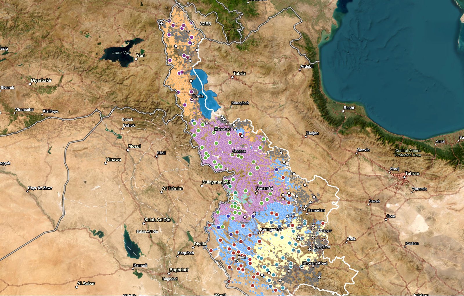
2. The Dialect Map: A Linguistic Gradient
Travel from the Turkish border in the north to the plains of Ilam in the south, and the language on the street shifts three distinct times.
The Northern Belt (Kurmanji): In the northern reaches of West Azerbaijan, encompassing cities like Urmia, Maku, and Khoy, Northern Kurdish (Kurmanji) is dominant. While Kurmanji is the most widely spoken Kurdish dialect globally (dominant in Turkey and Syria and parts of Iraqi Kurdistan), in western Iran it represents a minority bloc, accounting for roughly 20 to 25 percent of the population. These communities are linguistically distinct from their southern neighbors, often sharing closer cultural ties with Kurds across the Turkish border.
The Central Heartland (Sorani): Moving south into Mahabad and the entirety of Kurdistan Province (Sanandaj), the language shifts to Central Kurdish (Sorani). Representing 40 to 45 percent of the population, this is the literary and academic prestige dialect of Iranian Kurdistan. It serves as the lingua franca for the nationalist movement and dominates the media landscape.
The Southern Mosaic (Kalhori, Laki, and Feyli): Cross into Kermanshah and Ilam, and Sorani fades. Here, Southern Kurdish varieties (including Kalhori and Feyli) and Laki take over. Together, these southern dialects account for roughly 30 to 35 percent of the populace. For decades, state policy has attempted to classify these dialects as distinct languages separate from Kurdish, a narrative contested by local activists.
3. The Religious Map: The Sectarian Split
The most significant fracture line revealed by the data is religious. Unlike Kurdish populations in Turkey or Syria, which are overwhelmingly Sunni, Iran’s Kurds are sharply divided.
The Sunni North and Center: Approximately 60 to 65 percent of Iranian Kurds adhere to Sunni Islam (Shafi’i school). This bloc correlates almost perfectly with Kurmanji and Sorani-speaking areas in West Azerbaijan and Kurdistan Province. For these communities, identity is doubly marginalized: they are an ethnic minority within a Persian state and a religious minority within a Shia theocracy.
The Shia South: Moving south into Kermanshah and Ilam, the demographic flips. Roughly 35 percent of the population, primarily speakers of Southern Kurdish and Laki, are Shia. This shared religious identity with Tehran has historically created a complex relationship between the state and southern Kurdish tribes, occasionally insulating them from the harsher sectarian policies faced by their Sunni neighbors.
The Yarsan Enclave: The map also highlights the Yarsan (Ahl-e Haqq), a distinct religious minority constituting 3 to 5 percent of the population. Concentrated in the Dalahu region of Kermanshah, the Yarsan represent one of the oldest religious communities in the Zagros, maintaining traditions that predate modern sectarian divides.
4. The Administrative Map: Borders vs. Identity
The final layer is political. The administrative boundaries of these four provinces do not neatly contain the Kurdish nation.
In West Azerbaijan, the map reveals a stark east-west divide. The province is administratively shared with Azeri Turks, creating a mixed demographic zone along the shores of Lake Urmia, a frequent flashpoint for ethnic tension over land and resources.
In Ilam and southern Kermanshah, the Kurdish population blends into Luri and Arabic-speaking populations of Khuzestan and Lorestan. The rigid provincial borders on a standard map often disguise these fluid transition zones, where mixed villages are the norm rather than the exception.


